Merriton Rest Area – Snowtown – Port Wakefield – Balaklava – Owen – Hamley Bridge – Freeling – Hamley Bridge – Gawler Belt
It’s Good Friday and I really don’t want to be on the main highway for long so I head to Port Wakefield via Snowtown (I find a Pharmacy with a Newbery so send a text to Shelly) and tour around Snowtown. There is a large blade from the wind farms in the main street and a very well kept park. I head into Port Wakefield in time for lunch and leave the highway for a lesser road towards Balaklava. This town has a really inviting streetscape and the usual great stone buildings – several hotels and banks dot the main street. The racecourse is very green as is the school oval – unusual as all else is very dry.
After Balaklava I head to Owen which is in the Agricultural belt and was established in 1878 – once a thriving railway town, the town’s population is now around 400. They have photo information boards in the main street which I find very informative. The gate and fence at the back of the display are from Woods siding, only 5 klms north of Owen. I drove through Hamley Bridge to check out my stop for the night at the Oval, not much in Hamley Bridge except a couple of stunning old bridges.
I headed to Freeling for a beer at the Gungellan Hotel (McLeod’s Daughters’ fame) but the pub was shut – Good Friday. I explored the town, which was established in 1860, and claims to be the home of agriculture (evident in the beautiful cropped country which surrounds it), and found a really beautiful Lutheran Church so the trip wasn’t entirely wasted, even though I’d have loved to have had a beer for Danette and I!! The Op shop has some interesting McLeod’s memorabilia and has a great name – “Someone might like it”. The country around Freeling is rolling golden fields so I’m reminded of the series – trying to see Alex riding across the field but no luck!!
I went back to Hamley Bridge, got a piece of Fish for tea at the takeaway and headed for the Oval, but decided not to stay. I head Gawler to Colleen and Jims’ – my first night drive on unfamiliar roads. It is so great to catch up with them and we talked till late catching up on all the news. I ended up spending the Easter Break at Gawler, Justin and Jenny came up from Adelaide and we went to dinner on Sunday night – an amazing weekend – thanks to friends and family.

Balaklava Streetscape

Balaklava Welcome

Balaklava Bank

Owen Information
 Balaklava House

Owen Pictures

Owen Railway Gate

Hamley Bridge Welcome Sign

Hamley Bridge Rail Bridge

Hamley Old Bridge

Freeling Country

Freeling Welcome Sign
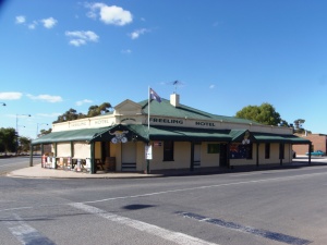
- Freeling Hotel


Gungellen Hotel

Gungellan Bar Mat

Freeling Op Shop

Gungellan Town Hall Sign

Freeling Streetscape

Freeling Park

Freeling Lutheran Church

Where’s Alex?